Looking Backwards at Route 128
American Psychogeography I: From Saint Botolph to the Road Warriors

[This long essay on Route 128 MA is to be published in three parts on March 25, April 2, and April 9 2026.]
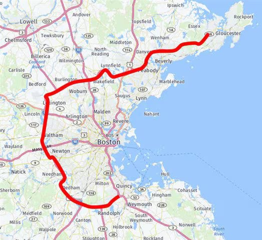
In the classical world it was said that all roads led to Rome. In America, all roads lead away from Boston. It was the place where revolutionaries conspired to overthrow the bent British monarchy, and the first to liberate themselves from the rule of the corrupt crown. One of the roads that leads from Boston, and around it, is the sacred track known as Route 128, the beltway that loops around the city and through its suburban towns. It was one of the first highways of this kind to go around a city and enclose it with the traffic of automobiles. Taking a journey along this road is one way to peer into the subconscious layer of a key birthplace in both the liberty of our nation, and the incarceration of our freedoms under the throes of the military industrial complex. While driving along its unremarkable everyday asphalt, while motoring alongside its concrete dividers, while jumping on and off its entrance and exit ramps, this winding may not seem cause for much reflection, yet its belligerent psychohistory has cut dark grooves into the recesses of the American mind, and the fruits of its industry have colored our dispositions, our obsessions, our collective neuroses.
The area of psychogeography, first developed by the Lettrist International and expanded by Guy Debord and his fellow artists and political thinkers in the Situationist International (SI) in France, has gotten its strongest foothold in England. Debord defined psychogeography as “the study of the precise laws and specific effects of the geographical environment, consciously organized or not, on the emotions and behavior of individuals.” In England its key practice, a form of urban walking known as the derive, or drift, has been championed in a variety of subcultures ranging from those surrounding the art of field recording as applied to electronic music, on the one hand, where the recordings were thought to capture some essence of the landscape, and literature on the other, where experiences, impressions, and history got distilled down into words.
Psychogeographical practice retains a strong foothold in England. This came in part from the establishment of the London Psychogeographical Association in 1957 by Ralph Rumney, who had been involved with Lettrism, the avant-garde art group COBRA, and went on to become one of the cofounders of the SI. Later, on the musical side it was taken up by the likes of Drew Mullholland and his Mount Vernon Arts Lab project, among many others. On the literary side of things, writers such as Peter Ackroyd, Stewart Home, Will Self, and Iain Sinclair have made extensive use of the concept to explore the resonance between the hidden histories of place and its psychic undercurrents.
While practitioners of psychogeography do exist in America, where the influence of Situationism can be seen in the work of Gary Warne and his formation of the urban exploring group the Suicide Club, whose members included John Law, co-founder of Burning Man, it has never achieved the same kind of popularity in the underworld of the arts as it has in England.
Consider this an investigation into a distinctly American psychogeography that travels through layers of time and the psychic imprint of the various personalities along Route 128 and the city it contains, and the suburbs it borders.
SAINT BOTOLPH OF SHAWMUT
The city of Boston is situated on the Shawmut Peninsula, a place shaped by the slow time of glacial erosion and moraine deposits. Much of the rest of what came to be known as the state of Massachusetts was shaped by the same gradual but all pervasive forces. The state itself was named after the Massachusett tribe, one of a number of tribes and bands that made their home in the region. Before the European migration and the great slaying of the trees, before the cars came it was covered in the green of a dense forest. Under the boughs and leaves animals left behind traces through the brush. Those traces turned into trails padded by humans, then into dirt and gravel roads. Now asphalt, concrete, plastic wrappers, empty cups and bottles litter the outside of the Stop ‘n’ Shop’s and corner markets leaving behind the traces of empty calories from empty consumption.
The first Anglo settler of the area was an Anglican reverend named William Blaxton. He stayed there until the Puritans arrived. Those Puritans had just left behind a country dominated by Anglicans and they didn’t much care for the others faith, even though they were all Christians. Theological differences rankled the air and caused Blaxton to move on to what is now Rhode Island. He had called the town he settled Shawmut. The name Shawmut came from the Algonquian word Mashauwomuk. It isn’t clear to us now, exactly what this word means. The Native Americans used the area on a seasonal basis for the most part. Their religions, not being based on the “one true book” and its interpretation, didn’t lend themselves to theological infighting.
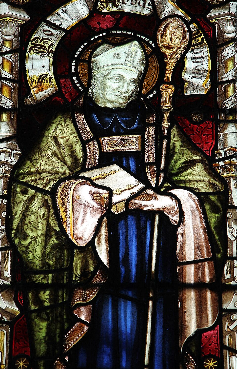
The name Boston itself comes from St. Botolph, its patron saint, and it was given to the city by yet another Puritan settler, Isaac Johnson. He made a home for himself in the part of the area known as Charlestown, and became its leader. His last official act before he died in the autumn of 1630 was to give a proper name to this settlement just across the Charles River. He settled on the name Boston, after the hometown in Lincolnshire where he, his wife, and John Cotton (grandfather of Cotton Mather) had left behind in England. Before Cotton Mather came to America, he’d served as a rector at the St. Botolph church. St. Botolph himself was an abbot who died around 680 and is known as being the patron saint of boundaries. In the traditions of the church, he also governs trade and travel, along with certain aspects of agriculture. As the patron saint of boundaries St. Botolph is a fitting guide to invoke when considering the entire notion of an American psychogeography, and in particular the boundary loops and ring roads surrounding the cities. It seems the influence of St. Botolph and this associated with him immigrated over with the Johnson and Cotton when they came over to this land.
LOOKING BACKWARDS AGAIN
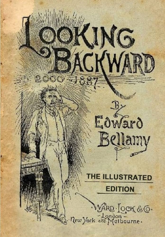
To introduce the next part of the story, the first developments of Route 128 as anything more than a collection of preexisting roads, we have to fast forward. After Tea Acts and Tea Parties and Revolutions and the War of 1812, after successive waves of immigrants, Irish, Italian and Jewish to name just a few, after the establishment of MIT in 1861, after the Great Boston Fire of 1872, a utopian scifi yarn by Edward Bellamy was published in Boston in 1888. Looking Backward: 2000-1887 was the story of a man who is put into a hypnosis induced sleep in the year 1887 and wakes up in an America that has been transformed into a socialist Eden.
After a trickle of initial sales and minor local success, the book started selling like hotcakes after its original publisher was bought up by the burgeoning behemoth Houghton, Mifflin & Co and a new slightly edited version was released. Labor organizers, socialists and nascent communists all began to praise and pontificate about the book. His book even had an influence on urban planning, through its descriptions of his idea of what Boston would be like in the future.
Not all Socialists were happy with the influence of Bellamy, even among the socialists. The multi-talented genius William Morris thought Bellamy’s ideas were poppycock, and said he had no real idea “beyond existence in a great city.” In his second book, Equality, published in 1897, Bellamy perhaps sought to amend the criticism from Morris and wrote of regional cities connected by high speed transport to rural villages on a continuum of development, while keeping the regional characteristics of each place intact.
When these book fell into the hands of Ebenezer Howard, a British man who’d relocated to America’s heartland, it kindled a fire in his brain. It wouldn’t be the last time life imitated art. Howard had tried his hand at farming in Nebraska, but he was unequal to the difficult task, and relocated to Chicago, where he found work as a reporter, work more suitable to his talents. He arrived not long after the city had been decimated, some may say purified, by Chi towns own great fire of 1871. In its aftermath he saw how the central business district was regenerated, and he was also witness to the subsequent growth of the cities suburbs, and he started thinking about those suburbs quite a bit. His daily work as a reporter took him into the courts. It was here that he saw firsthand the many social problems of his day. This face to face interaction with those suffering hard times continued when he returned to England in 1876. His mind was already under the sway of the Transcendentalist movement. He had been a great admirer of Ralph Waldo Emerson and Walt Whitman, and was said to have met them both. By the 1880s he was fully invested in investigating the options for alternative living available in his day. This brought him into the socialist and anarchist milieu and he started working on his own treatise, To-Morrow: A Peaceful Path to Social Reform first published in 1898.
There were some things in his book that just didn’t click until he read Bellamy. His head had been full of ideas about economic reform, but hadn’t given as much attention to the urban environment and its effects on humanity until he devoured Looking Backwards. Howard now had a vision for sustainable, self-sufficient communities that would combine the best of life in town with life in the country. After cogitating on the pros and cons of rural and city life, he sought a way to bring all the good attributes together, while diminishing the negative. He called his vision a Garden City. In 1902 his book would be republished as Garden Cities of To-Morrow. A key feature of his vision was open belts of nature, parks, countryside with industry kept in separate zones, but trees and wide open spaces everywhere. Further, each community would be planned and managed by the community. Self-governance and self-sufficiency went hand in hand.
At first people scoffed at his ideas, but later people started adopting them in some instances and specific planned communities, while certain aspects got folded into the designs of the worlds growing suburbs. Reformist members of the British Labor government were tickled pink by the respective works of Bellamy and Howard and their subsequent ideas around urban planning trickled into the discussions and debates of politicians, and eventually earthed into the land itself through new developments and restructuring.
Back in Boston, the journalist and poet Sylvester Baxter took up Bellamy’s ideas and helped implement them. He was a founder of the first “Nationalist Club” dedicated to their promulgation. At the time a leftist populist tide was rising and 165 of these clubs had been founded around the United States by 1891. It was only a few years before they merged with the Populist Party itself. Baxter was a man of many energies and he became a champion of the idea that swathes of land outside the confines of a city should be left wild and untouched by human hands. As an advocate of public parks and the use of the land for the recreation and pleasure of the citizens, he saw a connection between the anti-capitalist sentiment of the day, and the desire to keep the land out of the hands of the robber barons corporate lords of the Gilded Age. Baxter became a secretary for the Massachusetts Metropolitan Park Commission in 1892, and it was the work they did that led to the led to the creation of parks on a city scale, all under the influence of Bellamy’s book and the dream of creating a convivial place to be shared by community.
ROAD WARRIORS
As the twentieth century unrolled, so did the roads. The traces were already there, left by animals who walked and ran across the land, followed by the humans of the First Nations. When it rained, many of these trails became rivers of mud. In time they would become what the progressive electronica outfit Church of Hed calls “rivers of asphalt.”
Many of the very first roads in America were worn into muddy ruts by the march of the military, taking over those ancient and storied footpaths in the process of extirpating those very same Natives whose trail they followed. The railroad had helped accelerate the vast westward expansion of the pioneer era. It was only a few decades later as the twentieth century dawned when the car hedged its bet against the horse and buggy. The conditions of existing paths weren’t suitable for the new industrial machine. Motorheads and car salesmen began to advocate the government to improve the roads.
The expansion of the postal system had a role to play as well. If mail, and the new products multiplying in factories, were to be delivered to those who’d staked a claim in the hinterlands of America, road conditions would have to be improved. Starting in the late 19th century, but beginning officially in 1906, the United States Post Office set up the Rural Free Delivery program to take mail to farmers and others in the remote countryside. Not everybody was on the same page about this program. Private delivery men who got paid to take mail to distant addresses didn’t want to lose their livelihood, as did the shopkeepers and others who charged small fees to hold on to letters for later pickup when folks came into town. Politicians started hawking the idea of free mail delivery as a way to pick up votes for themselves, and expand the territory of who would be voting for them. The nation’s oldest agricultural organization, The Grange, championed the cause as it helped farmers stay in contact with the rest of the country, and in the end, it was adopted.
Road at that time still weren’t much more than trails. They were dusty when it was dry, and muddy when it rained. A car easily got stuck in the mud, just as wagons had in the past. Automobile travel was an adventure. With few mechanics or repair shops, every driver had to bring their own kit of tools and tire patching gear. In case they were stranded, they’d need to have extra food on hand, and without knowing where they would next fuel up, they had to travel with their own extra gas. Building up roads and service stations was essential if the early car fanatics were to get on their way.
By 1913 Henry Ford’s assembly line had ramped up car production. President Woodrow Wilson sensed his own political opportunity in the growth of the car, which needed the “rivers of asphalt” to truly thrive, and campaigned on road building as part of his platform. Wilson contended that “the happiness, comfort and prosperity of rural life, and the development of the city, are alike conserved by the construction of public highways. We, therefore, favor national aid in the construction of post roads,” and as ever, “roads for military purposes.” In 1916 he signed the Federal Aid Road Act, the first federal legislation to put money towards highway building.
The act established a Federal organization of Roads and Rural Engineering, later changed to the Bureau of Public Roads (BPR), and the following year ten different districts were established around the country. Each area was tasked with construction of Post Roads into their rural zones with cooperation from highway departments in each state. They were also given the job of surveying, building and maintain National Forest roads in collaboration with the Forest Service, a connection that would prove to be of lasting relevance.
The need for improved roads from the military perspective had been evident to the Army since World War I. Railroads had failed to get materiel and other logistical supplies to their destinations, and a truck convoy from Toledo, Ohio to Baltimore, Maryland had to be implemented. Numerous obstacles ensued that delayed the delivery of the war machines.
In 1919 another convoy with the Motor Transport Corps tackled the still young Lincoln Highway, the first Transcontinental Road, masterminded by automotive maverick Carl G. Fisher. It had been built on funds largely raised from private capital. At the time the Lincoln Highway was still unpaved in huge swathes between Illinois and Nebraska. What bridges there were even had to be destroyed and rebuilt to enable the passage of the military might. At the time Dwight D. Eisenhower was a Brevet Lieutenant Colonel and he had joined the convoy, “partly as a lark, and partly to learn.” It took the soldiers two-months to travel across 3,400 miles of rugged road. It’s no wonder Eisenhower later became such a big proponent of America’s next iteration of high-speed travel, the Interstate Highway System. His interest was specifically for its role in war and defense.
After this operation it was clear to the concerted interests of the government, military, and corporations (the embryo of what would become McGovCorp and the Military-Industrial-Complex that Eisenhower himself warned about), that the highways needed further development for smooth transcontinental travel. Developing and tapping North America’s vast natural resources wasn’t far from their minds either. The conservation movement of the time was also interested in opening up the wilderness to leisure and recreation activities, as well as curbing the untrammeled exploitation of the natural landscape. All of this led to the development of the Federal Highway Act of 1921, a vast expansion of the roadways that posited to further the creation of a complete coast to coast system, signed into law by President Warren Harding.
Thomas H. MacDonald headed the BPR from 1919 to 1953. One of his first efforts related to the new legislation was to get the Army to compile of a list of all the roads that they thought would be of “prime importance in the event of war.” With list in hand, he sent out the United States Geological Survey to get detailed information and measurements of the routes. Army General John J. Pershing was to put all of this together into a map. The result was the first topographic map of the nation, the Pershing Map, gargantuan at 32-feet long. Pershing presented the work to Congress in 1922.
The main roads of concern were on the East and West Coasts, along the border of Mexico, and the border of Canada around the Great Lakes, and the asphalt started being poured. Nobody seemed to care too much about the roads in the South. The oil rich fields of Oklahoma and Texas had yet to get pumping, and priority was given to transporting coal and steel from the east to the ports. Florida was likewise ignored for the most part. The military thought that any hostile forces landing there would be swamped without much ability to move northwards.
In the meantime a New England man had been dreaming of another way the unique landscape of North America might be connected together through trails and parks and “townless highways.” His name was Benton MacKaye and in 1921 his article “An Appalachian Trail: A Project in Regional Planning” was published, a first step towards making the Appalachian Trail we know today a reality. He would also try to leave his mark on the beltway road that was soon to cinch Boston up in its concrete and asphalt loops.
.:. .:. .:.
We will catch up with Benton Mackaye, and some of his fellows in the Regional Planning Association of America such as Clarence Stein and Lewis Mumford in the next segment of this essay.
.:. .:. .:.
The writings presented here will always be free, but you can support my work by passing the essays on to others, and sharing the links to other sites and telling your friends. I have also set up a Buy Me A Coffee page, which you can find here if you would like to put some money in my rainy day coffee jar. You could also buy my book The Radio Phonics Laboratory: Telecommunications, Speech Synthesis, and the Birth of Electronic Music, or my poetry book Underground Rivers, if you want to support me.
☕️☕️☕️
Thank you to everyone who reads this and helps support the universalist bohemian art life by keeping me caffeinated and wired.